174
174
Dec 4, 2012
12/12
by
KPIX
tv
eye 174
favorite 0
quote 0
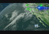
napa 47. we have a weather maker on the way. unlike the three that got you soaked over the past five days. this one is not as wet and it's being deflected just a bit to the north by a building area of high pressure. this high will be a player in the weather for the next seven days. it's going to bump the storm track up to the north. when rain moves through tomorrow it will be a glancing blow. the heavy rainfalls will stay away. you'll get showers. you'll get wet tomorrow into wednesday but not soaked. flooding is not a concern. rain on wednesday primarily but flooding is not a problem. oakland 62 tomorrow. santa clara 63. san jose 63. pleasant hill 62 and vallejo also 62 degrees. looking at your extended forecast calling for a lot of rainfall to move in. light to moderate rainfall tuesday and wednesday. then we dry out thursday through sunday looks mainly dry. and that's your cbs 5 forecast. >>> why kate middleton's morning sickness could be a sign that she's pregnant with twins. ,,,, bump, on kate middleton? ths magazine cover
napa 47. we have a weather maker on the way. unlike the three that got you soaked over the past five days. this one is not as wet and it's being deflected just a bit to the north by a building area of high pressure. this high will be a player in the weather for the next seven days. it's going to bump the storm track up to the north. when rain moves through tomorrow it will be a glancing blow. the heavy rainfalls will stay away. you'll get showers. you'll get wet tomorrow into wednesday but not...
296
296
Dec 4, 2012
12/12
by
KPIX
tv
eye 296
favorite 0
quote 0
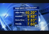
other areas napa 10" of rain, kentfield nearly 10." 7.5" for danville. not completely rain-free. it's not going to be a flood producer. it's not going to be anything compared to what we had over the weekend but there is some rain being tracked now on hi- def doppler that will arrive tomorrow. perfect timin. the national weather service talked about atmospheric rivers today. we call them the pineapple express storms. they are going to set up four different monitoring sites in california one of them in bodega bay the first one that opened up today. they are going to measure low level winds, relative humidity and soil moisture and here's the benefit to you. >> we have announced the development of a new system for measuring atmosphere ever rivers as they hit california. the injured to help science and forecast these storms like we just saw the last couple of days. >> and the benefit for ought home especially if you live near a river betting flood forecasts and also snow versus rain forecast to be able to pinpoint that snow level all of that beginning today right here in california. f
other areas napa 10" of rain, kentfield nearly 10." 7.5" for danville. not completely rain-free. it's not going to be a flood producer. it's not going to be anything compared to what we had over the weekend but there is some rain being tracked now on hi- def doppler that will arrive tomorrow. perfect timin. the national weather service talked about atmospheric rivers today. we call them the pineapple express storms. they are going to set up four different monitoring sites in...
136
136
Dec 4, 2012
12/12
by
KPIX
tv
eye 136
favorite 0
quote 0
napa 47. oakland down to 51. you will wake up tomorrow morning to 49 in redwood city and mountain view, san jose 50. a little above normal because of the cloud cover that's moving in. so there is another weather system heading to the bay area. there is also juice in the atmosphere and there's an area of high pressure that's sendingle storm track just far enough to the north that the heavier rainfall will move into far northern california and we are just going to get some light to moderate rainfall. it's a subtle change but enough of a change to alleviate flooding concerns around here in the bay area. so we have a storm system moving by tomorrow. we'll have a front dragging through but any heavy rainfall will likely stay away. you're just going to get plain old rainfall. that's it. on-and-off rain throughout the day. flooding not a concern. this is the long- range outlook. the entire west coast from oregon to mexico is forecast to be drier than normal so you want some dry weather clear things out? after wednesday
napa 47. oakland down to 51. you will wake up tomorrow morning to 49 in redwood city and mountain view, san jose 50. a little above normal because of the cloud cover that's moving in. so there is another weather system heading to the bay area. there is also juice in the atmosphere and there's an area of high pressure that's sendingle storm track just far enough to the north that the heavier rainfall will move into far northern california and we are just going to get some light to moderate...
122
122
Dec 4, 2012
12/12
by
KPIX
tv
eye 122
favorite 0
quote 0
east bay numbers up into the 60s, as well. 62 napa valley and 62 in vallejo. maybe a couple of light sprinkles into santa rosa and 61 degrees there and 62 in san francisco. next couple of days, a little bit wet one more time and looks like we'll dry out thursday and friday. and this weekend looks dry but keeping cool temperatures in the forecast. that's a look at weather. let's check traffic with gianna. >> thank you very much. we are dealing with some mass transit delays this morning especially with muni. they are working on getting all lines back on track that were affected by the power outage and accident yesterday. hoping to have everything good to go by 5:00 this morning. after that, though the n-judah and j-church lines will still be affected. if you typically take those lines, they will be rerouted at church and duboce so plan for that. the rest of mass transit looking good. no delays on bart. caltrain, ferries and ace train on time. we are dealing with a full freeway closure full for construction eastbound 4 through antioch right at loveridge hoping to
east bay numbers up into the 60s, as well. 62 napa valley and 62 in vallejo. maybe a couple of light sprinkles into santa rosa and 61 degrees there and 62 in san francisco. next couple of days, a little bit wet one more time and looks like we'll dry out thursday and friday. and this weekend looks dry but keeping cool temperatures in the forecast. that's a look at weather. let's check traffic with gianna. >> thank you very much. we are dealing with some mass transit delays this morning...
273
273
Dec 7, 2012
12/12
by
KPIX
tv
eye 273
favorite 0
quote 0
napa 43. mid-40s with fog likely for concord, livermore. fremont 45. fairfield foggy toward travis air force base tomorrow at 44 degrees for your overnight low. what we're looking at right now is a high pressure. we have a lot of low cloud cover and fog in the central valley. that will be prevalent over the next couple of days and tomorrow morning especially, some of that fog will work its way back inland so watch out north bay and east of the east bay hills out toward the 680 corridor. you will likely be foggy tomorrow morning. that's probably the only fly in the weather ointment if you will because it's all about high pressure. it's in the perfect spot just off to our west to give us a light northwesterly flow of air that's going to give us sunshine and dry weather and it's going to get our temperatures above normal. may not feel like it but it is early december where the average high is the upper 50s. you will be in the low to mid- 60s over the weekend three to seven degrees above average so watch out for the fog. if you want to set at large a coupl
napa 43. mid-40s with fog likely for concord, livermore. fremont 45. fairfield foggy toward travis air force base tomorrow at 44 degrees for your overnight low. what we're looking at right now is a high pressure. we have a lot of low cloud cover and fog in the central valley. that will be prevalent over the next couple of days and tomorrow morning especially, some of that fog will work its way back inland so watch out north bay and east of the east bay hills out toward the 680 corridor. you...
 Live Music Archive
 Librivox Free Audio
 Metropolitan Museum
 Cleveland Museum of Art
 Internet Arcade
 Console Living Room
 Books to Borrow
 Open Library
 TV News
 Understanding 9/11